Fieldwork has been divided into two sections, the first dealing with systematic field walking and the recovery of artefacts from the plough soil, and the second dealing with the results of subsequent geophysical survey. The latter has been largely, but not exclusively, based on the areas where field walking showed the most promising results.
Field Walking
The systematic walking of fields (with landowners’ permission) is best carried out soon after ploughing when the upper subsoils have been disturbed and buried material brought to the surface by the plough, typically pottery shards and fragments of building stone. Often a fresh shower of rain helps them to be visible on the surface. Fieldwalking usually necessitates gridding each ploughed field into squares and involves a line of people walking systematically collecting material and logging its position on a plan. When all the grids are fitted together it becomes possible to see where the main concentrations of material are and hence the likely location of archaeological sites. The smaller the grid the more accurate the distribution is likely to be.
There are a number of problems with field walking that need to be taken into account. Seasoned field walkers are well aware that some people, with the best will in the world, tend to spot fewer items than others. Also, walking across a field in a different direction or in different light from one day to the next can result in some objects being more visible. There are some arguments too as to whether a focus of material is best reflected by the total number of items recovered, or by the total weight of items recovered. Overall, field walking is best used as a coarse but very effective tool for locating the general position of archaeological sites that might otherwise remain unnoticed.
A significant field walking exercise known as The Edgehill Project was set up by a group of keen archaeologists, historians and ecologists in 1995 in order to better understand settlement and land-use in an area of south Warwickshire close to the Edgehill escarpment. The project mapped scatters of Romano-British material along with some potential Iron Age pottery and scatters of worked flint. Most sites also contained fragmented marlstone rock from the nearby escarpment and the occasional terracotta tile, including box flue tile. The distribution of this material often indicated severe disturbance due to medieval ridge and furrow activity and recent cultivation.
The project team worked closely with the staff at Warwickshire County Council (WCC) and the results are incorporated in the WCC Historic Environment Record (HER). The HER mapping also includes those items discovered by other means, mostly by metal detectorists, and reported to WCC under the Portable Antiquities Scheme.
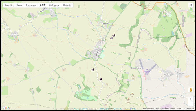
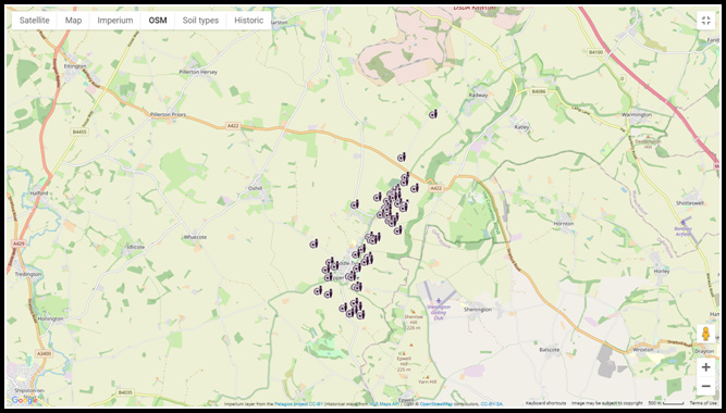
The following maps are those produced by the Portable Antiquities Scheme based on Kevin Wyles’ fieldwalking from 1968 and metal detecting from 2015. They illustrate known prehistoric activity in the area on a period-by-period basis. Subsequent geophysical survey (below) has been able to give a more detailed indication of the size and nature of some of them. The majority of find spots and sites lie to the east side of the ‘straight mile’ which runs north from Lower Tysoe where most of the fields had been used for crops rather than grazing and where resultant ploughing had brought pottery and other items to the surface. The plots show the uneven distribution and changing pattern of settlement through time but are best viewed as being a sample of what Tysoe has to offer. The west side of the road, for example, may be equally rich in remains but has been ploughed less and hence not addressed yet by fieldwalking or geophysics. The majority of find spots and sites (including two Roman sites located by Kevin Wyles) lie to the east side.


Geophysical Surveys
One of the main techniques for detecting buried remains is by using geophysical survey. There are three main methods for doing this – electrical, magnetic and electro-magnetic (radar). They all respond to different aspects of the buried environment but have one thing in common, namely that they will only ‘see’ something underground if it is different from everything else around it. In other words they detect inconsistencies or anomalies in an otherwise consistent buried environment.
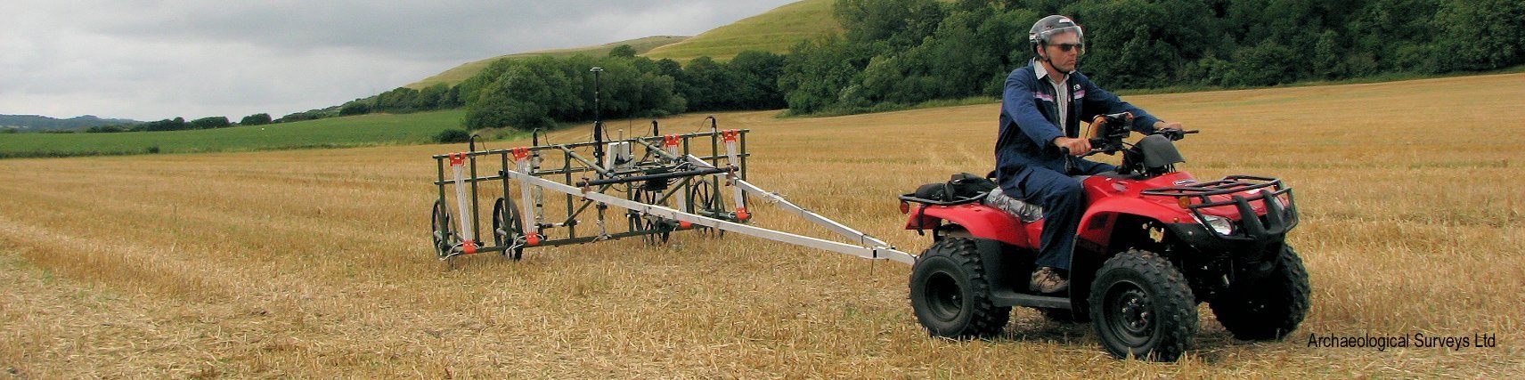
Measurements need to be taken systematically (say) every 0.5 or 1.0m over a given area. This can be done manually while walking or, more efficiently, by using wheeled machines which can cover large areas of land rapidly, log data automatically and plot position using satellite technology.
The most common electrical method is based on resistivity. This involves passing a small current into the ground between two metal probes and measuring the resistance to the current each time. The level of resistance to the electric current is normally a measure of anomalies approximately 0.5 -1.0 m below the surface. If readings are taken over an infilled ditch the resistance readings are likely to be low in relation to the norm because soil in an infilled ditch is usually quite damp. Moisture is a good conductor for the current and hence the resistance to the current is low. If, on the other hand, there are stones below the ground, then the readings will be higher than the norm because stone is dense, dry and a poor conductor. Resistivity is best in identifying linear features below the ground such as walls, ditches and enclosures. Simple systems are relative cheap to purchase but time-consuming to use. THRG has its own equipment and has carried out a small number of surveys in response to private enquiries.
The method used most effectively in Tysoe is that of magnetometry and has been carried out professionally by David Sabin of Archaeological Surveys Ltd., partly funded by a grant from the CBA Mick Aston Fund. David’s company used highly mechanised equipment to survey large areas of field, especially to the east of the ‘straight mile’ which leads out of Tysoe towards the A422. Magnetometry can detect subtle changes in magnetic response on or below the surface, for example if a magnetic soil has been disturbed and diluted with soil of a lower magnetism, or if soil of a higher magnetic content has been brought nearer the surface. The method is very sensitive, so sensitive in fact that the user needs to avoid wearing anything ferrous. It is especially good for picking up strong magnetic anomalies such as buried hearths or pits containing burnt material.
The third method, radar, sends microwaves into the ground and measures the time it takes for them to return. In a sense it identifies different densities of material below the ground. It has the great advantage of being able to ‘see’ through solid surfaces, for example concrete or tarmac, and can be used to detect anomalies at much greater depth than the other two methods. That said, there is a trade-off between depth of penetration and how clearly the anomaly can be seen. Radar is expensive and is best used for small areas, or indoors.
Geophysical survey will only detect what may be there according to the limits of the respective techniques. It is up to the operator to identify exactly what the anomalies might be and how old they are. The only way to prove or refute this is by excavation (or ‘ground truthing as some call it).
The detailed locations, results and interpretations of survey undertaken by Archaeological Surveys Ltd can be found by clicking on the following links while the map below indicates the general areas of interest.
The Roman History of Tysoe
Four Romano-British Sites, Tysoe, Warwickshire
A summary of some of the sites is included below, but readers are urged to consult these two main reports in order to identify full details of locations, method used, interpretation and technical aspects of the survey. In the following examples of geophysical work carried out in Tysoe, the images produced by Archaeological Surveys Ltd are by kind permission of David Sabin.

Summary
Research carried out by David Sabin in this area over the last 30 years has involved both geophysics and surface collection supported by metal detection. The local soils are particularly useful for magnetometry with very strong contrasting anomalies forming as a consequence of comparatively high levels of (magnetic) iron due to weathering of the highly ferruginous Marlstone Rock Formation present in the nearby Edge Hill escarpment.
The overall results indicate numerous enclosures, field systems and trackways surrounding core settlement areas. The complexity of many of the sites infers long periods of settlement, possibly from the Bronze Age (roughly c. 2500 – 800 BC) to the end of the Roman period (c. 400 AD), although one of the sites close to Tysoe church may also contain post-Roman features as Saxon pottery sherds were present in the fieldwalking collection. The earlier enclosures and ditches are rounded or oval, changing over time to the rectangular or square structures of the Roman period. Even in these early times it seems that the landscape was fully settled and exploited continuously right the way through the centuries. However, by the end of the first millennium AD the focus of settlement had moved to roughly where it is now and the fields became cultivated.
The following diagrams show the magnetometry results from a few of the sites investigated. The data is expressed in terms of lightness and darkness where darker equates to higher magnetic responses and lighter to lower magnetic responses, their differences being scaled to produce an optimum definition.

Survey at Downs Farm to the south of the village along the Epwell Road, a site identified by field walking by Kevin Wyles, located a complex area of enclosures and archaeological features covering at least 3.5 ha. The site is likely to have seen development over a long period with evidence for changes in the shape of enclosures and their periodic renewal resulting in a mass of anomalies. Other features include ring ditches, pits and trackways. It is likely that the anomalies represent a farming settlement with its origin sometime in the prehistory and continuing through the Roman period. Later ridge and furrow cultivation can be seen as strong parallel lines running across the field.


The locations of most of these sites were pinpointed from systematic field walking. Each field was divided into transects and walkers covered each transect collecting pottery as they went and recording its position. The above plot for Twenty-Seven Acres shows where the greatest density of Romano-British pottery was found. The enclosed area in the plot is where the field was rich with stone ploughed up from earlier buildings.
The geophysics data of the three site Twenty-Seven Acres, Madhill just south of the A422 at the base of Sun Rising Hill and Bean Hill across the road to the north, suggest that these sites contain numerous anomalies which would indicate phasing and occupation over a long period, probably extending from prehistory to the end of the Roman period. The survey at Madhill appears to show the location of a substantial building from the Roman period, later ridge and furrow cultivation can be seen as faint parallel lines running across the fields.


Magnetometry was also targeted on Windmill Hill, considered to be a possible Iron Age hill fort, and on circular cropmarks to the west of Tysoe. Although several anomalies of uncertain origin were located at both sites, no anomalies could be confidently interpreted as having archaeological potential. The white square on the plot is the location of the Windmill.

Magnetometry carried out over 7.8 ha to the north-east of Hopkins Farm located extensive anomalies relating to ditches and enclosures associated with Roman and possible prehistoric settlement and agriculture. Several small ring ditches, probably relating to former roundhouses, and small pit-like anomalies, possibly relating to post-built structures, were also located. Anomalies are likely to extend beyond the limits of the survey in all directions suggesting that the full extent of the archaeological remains is uncertain and could be considerably more than that surveyed. Later ridge and furrow cultivation can be seen as consistent parallel lines running across the field.
